

BRMB
Backroad Waterproof Map Squamish Chilliwack & Merritt
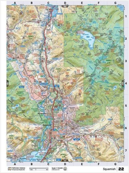
622098110005This recreation topographic map for the Squamish area highlights all the logging roads, trails and recreational Points of Interest including hunting, camping, hiking, mountain biking, canoeing, kayaking, backcountry skiing, wildlife viewing, ATVing, snowmobiling and more. No other map for the area provides you with this level of recreational or topographic detail. Covering 1,090 km2 (420 mi2), this 1:32,000 scale map measures 29 x 38 km (18 x 24 mi) and covers Squamish, Alice Lake Provincial Park, Garibaldi Provincial Park, Tantalus Provincial Park, Cheakamus River, Garibaldi Lake, Mamquam River and more! This map also covers the following Wildlife Management Units: WMU 2-5 Lower Mainland, WMU 2-6 Lower Mainland, WMU 2-7 Lower Mainland, WMU 2-8 Lower Mainland. Squamish - Vancouver Coast & Mountains BC is printed on demand at our office in Coquitlam (BC) and measures 61 x 94 cm (24 x 37 inches).
Reviews
Customer Reviews
This product has not yet been reviewed.


Share:
Share on Facebook Share on Twitter Share on Pinterest Tell a friend